
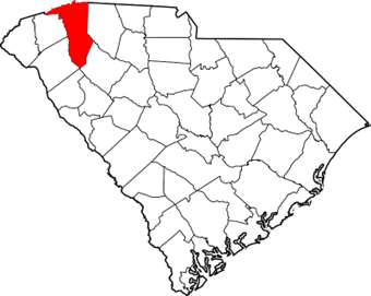
Greenville County, South Carolina

The Evolution of County Boundaries in South Carolina
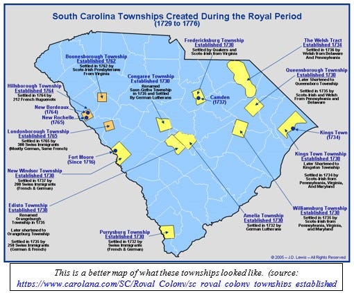
My first examination of the county boundary changes in South Carolina revealed that I had a lot to learn about how South Carolina was settled. These maps (mostly from https://www.mapofus.org) look very different from similar maps I’ve looked at for other locations I’ve written about in this series of blog posts.
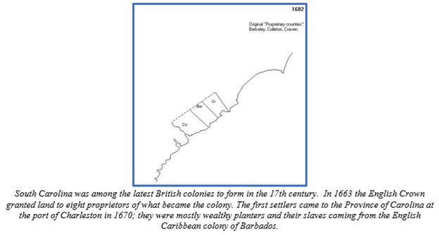
So I started reading. My observation was right – South Carolina was quite different. For one thing, the settlers of South Carolina perceived themselves to be (and were perceived as) a bulwark against the Spanish, whose settlements across the Caribbean and Gulf of Mexico were a threat to the British outpost in South Carolina. For another thing, the colonists in South Carolina were isolated from the rest of British North America. The population centers of Virginia and New England were far away. The settlement in North Carolina, around Albemarle Sound, barely existed and certainly did not provide any military support or trading partnership to South Carolina. The nearest significant economic base – the Virginia Colony along the Chesapeake Bay and its tributaries to the west – was almost 500 miles away by sea, and the trip would have taken at least 5 days. South Carolina felt as if it was on its own. Original drawings of Charleston show a fort – not a village, not a farming community.
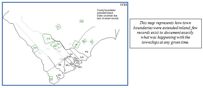
One source I read – The history of South Carolina under the proprietary government, by Edward McCrady – described the South Carolina colony as a curious amalgam of settlement patterns taken from the New England and Virginia colonies. South Carolina was settled as a planters’ colony, like Virginia, but with a town setting, like New England. But Charleston was the center of the colony in a way that Boston, for example, was not in Massachusetts. Although Boston was the largest and most important city in the colony, towns existed independently from Boston from the earliest days of settlement. In South Carolina, Charleston was the only game in town, so to speak. There was no local government – no structure of towns or counties – outside of Charleston until the first decades of the 18th century.
In addition, South Carolina differed from the other British colonies in North America in the characteristics of its settlers. The earliest settlers in South Carolina did not all come directly from England, as in the other colonies; more than half of them came to South Carolina came from England, to be sure, but by way of Barbados, where they had already established a colony. In many ways, South Carolina was a colony of the overcrowded British colony in Barbados. These settlers brought with them an understanding of colonial governance that had developed in Barbados, which was quite different from that mindset developing in the other colonies.
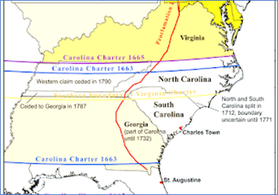
They started to develop commercial crops – primarily sugar and cotton. Pushing back the Native Americans in the Yamasee War (1715–17), colonists next overthrew the proprietors’ rule, seeing more direct representation in governing. In 1719, the colony was officially made a crown colony; North Carolina was split off and made into a separate colony in 1729. The original Carolina colony, founded in 1663, had included both North and South Carolina.


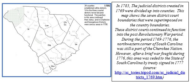
A (Very) Little History
This is what a local history source has to say about the founding of Greenville County https://www.greenvillesc.gov/DocumentCenter/View/1317/History-of-Greenville-PDF?bidId=
“The city of Greenville is situated on land that was once Cherokee hunting ground, closed to colonists’ settlement. About 1770, Richard Pearis, an Indian trader from Virginia who was living with a chief’s daughter, received about 100,000 acres of hunting lands from the Cherokees. Pearis set up a plantation on the banks of the Reedy River in what is now downtown Greenville. His Great Plains Plantation included a sawmill, grist mill, and stables together with a trading post.
“When the Revolutionary War came, the struggle in the South Carolina back country between Tories and Patriots was fierce. Pearis threw his support to the Tories and their Cherokee allies, and together they terrorized upstate Patriots. In retaliation, a Patriot troop raided his plantation, burned his mill and home, and briefly jailed him in Charleston. He never returned to the upstate, but he left his name on Paris (Pearis) Mountain.
“After the Revolution, the new state of South Carolina claimed the Cherokees’ territory and began distributing it to Patriot soldiers as payment for their wartime services. In 1786, the state legislature formed Greenville (originally spelled Greeneville) County, naming it for Gen. Nathanael Greene, the hero of the American southern campaign.
“The first owner of the land that became city of Greenville was Thomas Brandon of Union, who purchased 400 acres that had once been Pearis’s in 1784. Several years later, Lemuel Alston purchased Brandon’s holdings and additional acreage, amassing over 11,000 acres around the Reedy River. The General Assembly sited the county’s courthouse on Alston’s property in 1794. Three years later he platted 60 lots for a village he called Pleasantburg, with a log courthouse surrounded by a court square. He built his home, Prospect Hill, called by a visitor “the finest dwelling in the upstate,” at the crest of a sycamore-lined avenue north of Court Square. Alston’s lots did not sell well, and since the settlement was already called Greenville Courthouse, his choice of name didn’t catch on.”
My Ancestors in Greenville County
Here’s the pedigree chart for my direct ancestors in Greenville County:

This chart shows a small number of ancestors in Greenville. My 5th great-grandfather, Christopher Hunt (1728-1781) was born in Virginia and married Catherine Blasingame (1735-1781) in Virginia in in 1755. He and Catherine moved to North Carolina by 1757, when their first child, John Hunt (1757-1821) was born. John was my 4th great grandfather.
I know a fair amount about Christopher’s origins. His parents, Ralph Hunt (1693-1780) and Dianna Charity Anderson (1693-1789) were both descended from families with early roots in Virginia. Ralph’s grandfather, also named Ralph Hunt (1613-1675), had come to Virginia in the 1630s and settled in Charles Parish (which was to become York County).
One of Dianna’s great-grandfather, Richard Anderson (1585-1658), had also come to Virginia in the 1630s, settling in James City County. Another of Dianna’s ancestors, her grandfather Peter Massie (or Massey) (1615-1719), had also come to Virginia in the 1630s, when he settled in New Kent County.
Yet another of Dianna’s ancestors, her grandfather (my 7th great-grandfather) William Overton (1638-1687), was a relative latecomer to Virginia; he arrived in York County in 1669. His story is romantic, and I tell it in more detail in my Week 34 essay on New Kent County and my Week 52 York County essay. But here’s a teaser: his father, Robert Overton (1609-1679), had run afoul of Cromwell in England in the 1650s, and he ended up imprisoned on the Isle of Jersey off the coast of France. His family didn’t know where he was, so his son William came to Virginia to see if he had perhaps been exiled there. William’s girlfriend, Elizabeth Mary Waters (1654-1697), followed him to Virginia, where they married in 1670. William was a Protestant and Elizabeth was a Catholic; their love fell in the category of “forbidden” in England at the time, so they stayed in Virginia. William’s father Robert, by the way, had never come to Virginia. He was released from prison in the early 1670s and spent the rest of his life in England with his family.
Back to Christopher’s story.
Several other members of the Hunt family moved to North Carolina at about the same time as Christopher. Christopher had married Catherine Blasingame (1735-1781) (also known as Caty) in 1755. I don’t know much about Caty’s family, other than that they had been in Virginia for at least two generations before Caty’s birth. John Hunt (my 4th great-grandfather, remember) was born in Granville, NC, near the Virginia border, as were several of his siblings.
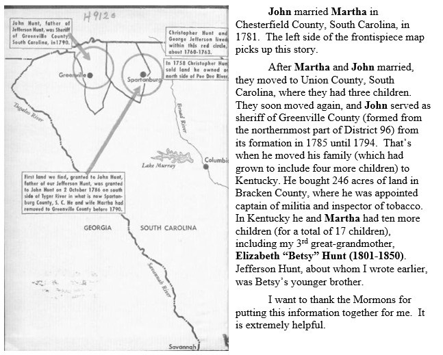
This is as good a time as any to acknowledge the benefit of having ancestors who are connected to someone famous. John had a lot of children between 1790 and 1810 – more on that later – but one of them was my 4th great-uncle Jefferson Hunt (1804-1879), who was to become an important figure in the Mormon settlement in Nauvoo, Illinois, and later when the Mormons moved to Salt Lake City. The Mormons have written extensively about Jefferson Hunt, and John gets a lot of attention in. these narratives. This is one reason I have this image, which is a hand-drawn map of the early life of John Hunt in Virginia, North Carolina, and South Carolina. It is the frontispiece of a 1958 book Captain Jefferson Hunt of the Mormon Battalion by Pauline Udall Smith. I retrieved this book from the Hathitrust web site.

The marriage between John and Martha was delayed for a few years because of the American Revolution; John was in the 1st Spartan regiment of the South Carolina militia during the Revolution, and he participated in the defense of the siege of Charleston, a British victory. Some members of John’s unit were captured during this siege, but I haven’t been able to determine exactly what happened to John. Other elements of his unit went on to fight at the 1780 Battle of Kings Mountain in South Carolina, but I haven’t been able to verify that John was there either.
Amazing. And so interesting. When I look back on my American history classes, it never occurred to me as a kid that towns didn’t just spring from the earth, organized and established. Great piece.