
Go West . . .

NOTE: I wrote this on Monday for publication this morning. By the time you read this, I’ll be in my local voting precinct, where I’m serving as an election officer for the day. The precinct I’m assigned to is in the cafeteria of a local elementary school — schools are closed because Election Day became a state holiday in Virginia in 2020. I was at the precinct last night for an hour or so to set up, and I got there this morning at 5:00 a.m. to do the final set-up (putting signs out, putting tape on the floor to direct voters, opening and double-counting ballots) so we’d be ready to open at 6:00 a.m. We do a lot of ballot counting during the day — not the completed ballots (they go in the machine) but the blank ballots. We double-count the ballots every time we open a package (the packages are supposed to contain 50 ballots but we count anyway), and at the end of the day the number of ballots that we counted out has to equal the number of ballots cast plus the open but unused ballots. We’ll be in the precinct until after the polls close at 7:00 p.m. This is a Long Day. Election officers don’t leave for meals and we don’t entertain visitors. We bring food for a potluck lunch — we take breaks in stages and go to a nearby kitchen to eat or drink something. We dress in politically neutral colors (I usually wear green or purple) and we don’t act out our partisan identities in the precinct. We are there to facilitate voting, not to campaign for our favored candidates. We have to stay until we all sign off on the accuracy of our process and the precinct chief says we can leave. We do get paid — I think it’s $125 for the day. If you ever want to know whether elections are trustworthy, I encourage you to become an election officer. They’re always needed.
It’s finally time for my Osher class for this semester. (This is late in the semester, which began in September.) It’s called “Go West, Young Man: Westward Expansion in American History and Mythology.” It starts this coming Thursday and will run for two more Thursdays – not on Thanksgiving, but on November 30 and again on December 7. I’ve taught this class twice before – once over Zoom in 2020, and the second time in-person in 2021. It’s been well-received in the past and I don’t have any reason to believe that it won’t be successful this year as well. But I’m still putting in a lot of work on it – tweaking and updating the content and the presentation to make it better. Or I think it’s better. I’ll have to wait and see. The class has more than 100 members, and I expect they’ll let me know if they like it. Osher members are not silent about what they like and don’t like.
You may have wondered about the word “mythology” in my class title. In the third class session, I focus on the cultural significance of “The West” – how the process of westward expansion creates a founding myth that Americans accept as fundamental to our national identity. We’ll talk about why our presidential candidates are photographed wearing cowboy hats, why we all recognize the Lone Ranger theme music, why “country and western music” is popular in places that are neither “country” nor “western,” and why the exterior of a Taco Bell looks like the Alamo.
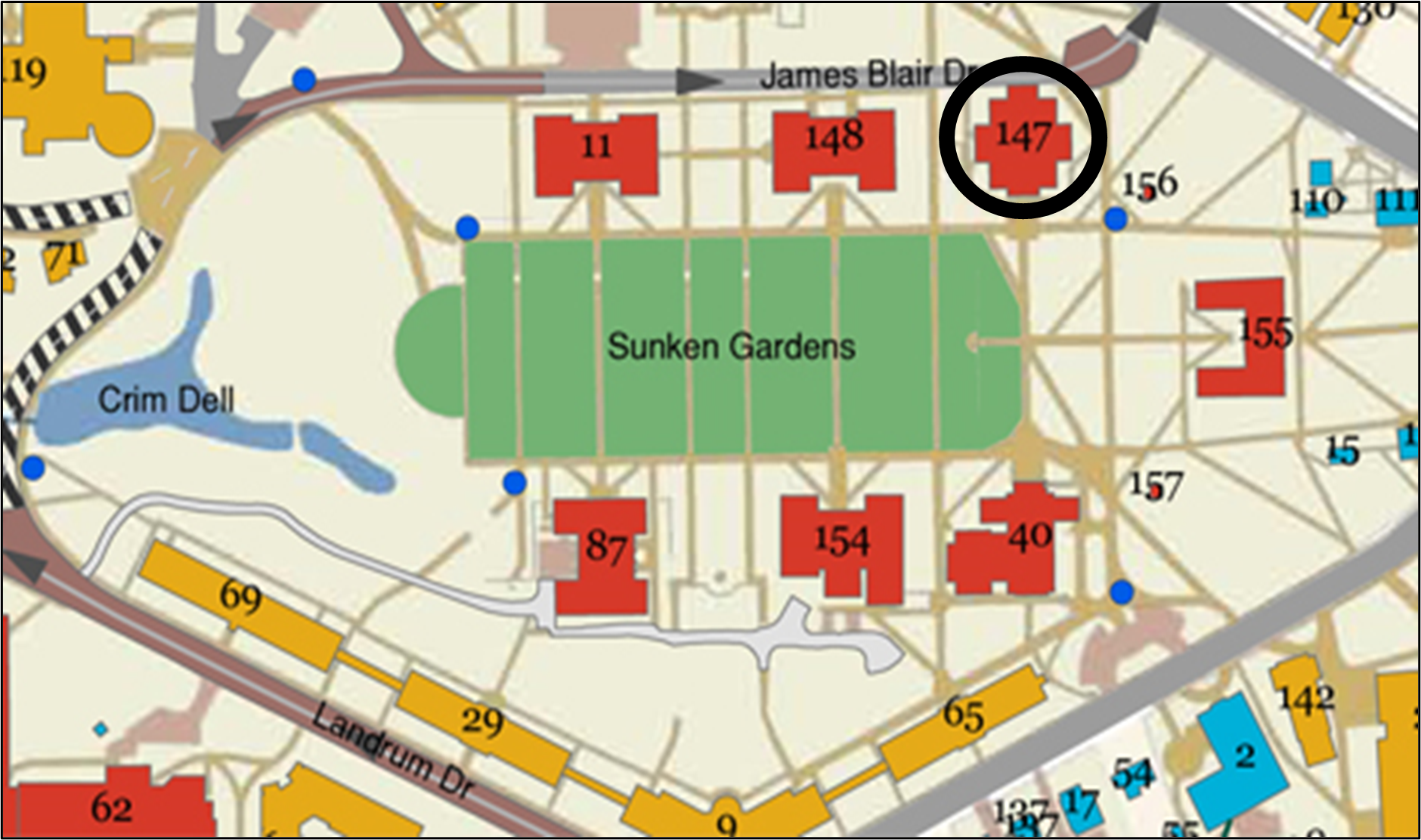
This semester will be slightly different from my earlier Osher teaching experiences. For one thing, I’m teaching the class in Tucker Hall on the William & Mary campus. I haven’t taught in this space before, and I’m looking forward to it. This building is on the “old” campus surrounding the Sunken Garden.
Second (and less importantly), my class runs from 2:30-4:30 p.m. – an hour later than our standard afternoon session. This is probably due to the college scheduling priorities. We depend on the college to provide our teaching spaces, and I’m guessing that this is the block of time the college made available.
My genealogy research got me interested in this subject a few years ago. I had done enough research to recognize that my ancestors moved around a lot. I had ancestors in 11 of the 13 original colonies before the American Revolution, but all of my direct lines had migrated to territory west of the Appalachian Mountains by 1850. I started researching a project I called “Over the Hill,” which I intended to focus on when, why, and how they moved over the mountains. I soon realized that I didn’t know enough about three things that would make all of this make sense: the conditions in the places they left, the process of moving west, and the conditions in the places where they landed. I backed away from “Over the Hill” and began to research these three elements of the story. This included taking a course on “Migration Patterns” through the International Institute for Genealogical Studies. After I completed this course, I decided to pull the information together to teach this course.
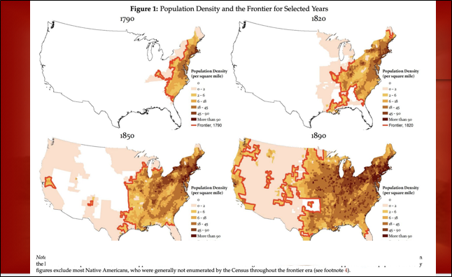
This week’s session focuses on the official, top-down, political history. In this class, I’ll focus on the legislation, treaties, and wars that enabled westward expansion. This is the type of history most of us are most familiar with. I’ll be using a lot of maps to illustrate how government-sponsored explorers moved to the West, how government money funded much of this expansion, how the expanding United States acquired land through war and sub-war violence, and how Congress passed legislation to legalize these acquisitions.
This will be a sweeping overview. Here’s one of the maps I’m using in the presentation:
Here are some more maps from my presentation:
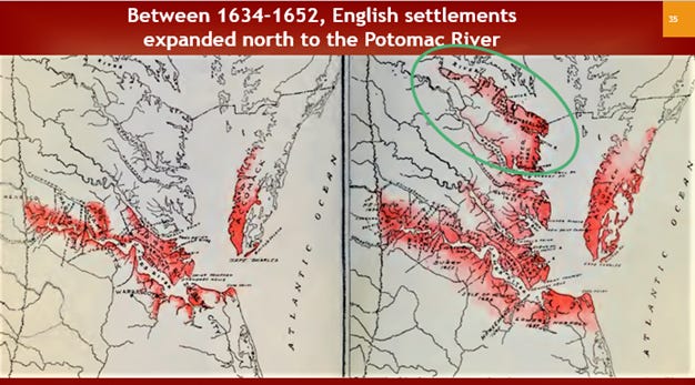
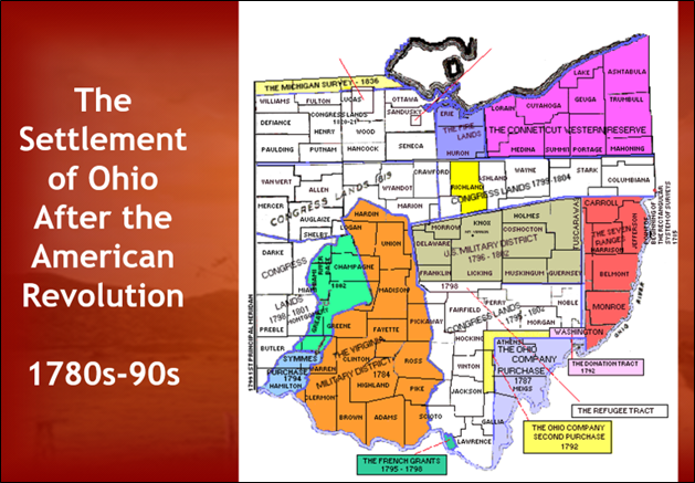
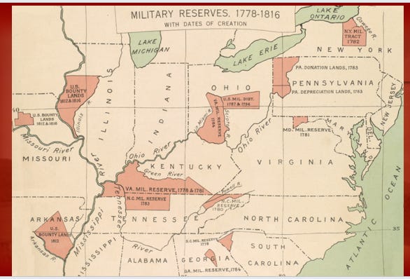

Can you tell that I really like maps?
Heigh ho, over there! I'll be in Toano today, smiling but not talking much to voters. I woke up with no voice this morning. Lovely. Love your Westward Ho! maps.
I’d say you like a lot of things. Thanks for all you do, and for the difference you make in the lives of those you touch. 😎