
Dutchess County, New York

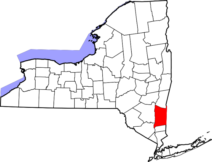
Dutchess County, New York (sometimes spelled Duchess County) was one of the original 12 counties formed by the Province of New York in 1683. It was named after the Dutchess of York, Lady Anne Hyde; she was the wife of King James II of England, who previously had been the Duke of York. Its location, stretching for 50 miles along the Hudson River north of New York City, has made it a pathway for natives and explorers for centuries. It borders the state of Connecticut, but the Taconic and Berkshire mountain ranges along that border impeded easy travel during the early colonial era.
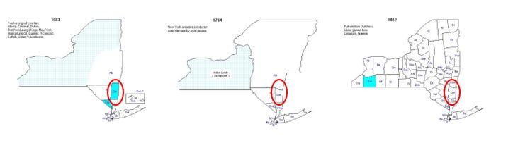
The Evolution of the Boundaries of Dutchess County
Once Dutchess County was formed in 1683, the boundaries didn’t change very much over time, as these maps (from https://www.mapofus.org/) illustrate. The last significant change was in 1812.
More Than A (Very) Little History
In other essays that are part of this genealogy project, I have devoted only a few paragraphs to a description of the historical setting for my ancestors’ lives. In this essay, I’m going to go into more detail, mainly because I want to write down some less-known elements of this history before I forget it. So bear with me.
Although the Hudson River had served as a highway for the natives in the area for centuries, it came to the attention of the English explorers of the east coast of America only in 1609, when explorer Henry Hudson first navigated it. Although he was English, Hudson was employed by the Dutch East India Company when he was exploring the Hudson River, and Holland took possession of the area.
The Dutch founded the colony of New Netherland in 1614, seven years after the settlement at Jamestown and six years before the Pilgrims came to Plymouth. When I began exploring the history of this colony for this part of my family’s history, I was surprised (and chagrined) at how little I knew about it. Apart from the fact that the settlers “bought” the land from the Indians for some small amount of “wampum,” that a peg-legged general named Peter Stuyvesant was involved somehow, and that the Dutch soon turned this colony over to the English (who named it New York) I knew nothing about this colony. Oh yeah, I also knew that the Grand Old Duke of York, who had 10,000 men, marched them up the hill and then he marched them down again. Never did figure out why.
When I realized that the Dutch held this colony for more than 60 years, through an important period in the early settlement of the American colonies, I was annoyed that I didn’t remember more about the colony’s settlement. I assumed that I had either been taught this material and had forgotten it, or that I had not been taught it because it was Dutch history, not English, and therefore deemed not important. History is, after all, written by the winners – in this case, the English.
I did not expect to discover that I was not taught this history because it was basically not well known to anyone, not even historians of the colonial Atlantic world when I was in school in the middle of the 20th century. In his 2004 book The Island at the Center of the World, historian Russell Shorto describes his discovery of the archives of the early Dutch colony. Much of what I say in the next section of this essay comes from this book.
Shorto initially found Dr. Charles Gehring, a historian who had spent almost 30 years studying an obscure archive of the early Dutch settlement, hidden away on the mysteriously unmarked eighth floor of the New York State Library in Albany. Written in loopy, almost indecipherable 17th-century Dutch script, the manuscripts Gehring was examining required the keen eye of someone with historical insight and the ability to transcribe and translate the language – skills that Gehring uniquely possessed. The initial result of Gehring’s work was the creation of the New Netherland Project, which has continued to support research into this colony. I have joined this organization — not so much because of my ancestors who lived in Dutchess County, but because of another ancestral line made up of Dutch settlers in Manhattan.
Gehring has devoted decades to the translation and analysis of over 12,000 handwritten sheets of records of this colony containing information previously unknown to scholars and history books. It was reassuring to know that I was unaware of the history of this colony because, by and large, no one knew the history of this colony. As Gehring translated the records of the colony, the things he discovered began to make their way into scholarly journals and into common knowledge that would eventually make its way into textbooks.
The Atlantic World In The 17th Century
The North Atlantic was a busy place during the 16th and 17th centuries. Mariners from Spain, France, Portugal, England, and the Netherlands were traversing the Atlantic in an ongoing quest to discover trade routes and the seemingly eternal goal – gold – in the lands that the improving navigational tools of the time allowed them to explore. This quest for treasure and trade turned into a competition for glory as these nations sought political and imperial dominance in Europe and beyond.
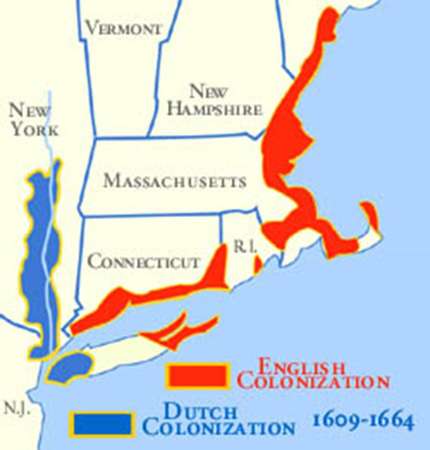
This competition extended into the Americas. Spain explored and conquered kingdoms in what we now know as Central and South America and the Caribbean; France explored Canada to the north and Florida to the south; Portugal competed with Spain in exploring South America until the Treaty of Tordesillas in 1494 divided areas of exploration between Spain and Portugal; England’s exploration focused on the Caribbean but also on areas of North America we now know as the United States and Canada; and the Dutch gained a foothold in this new land in the area we now know as New York and New Jersey.
Although Dutch exploration gets little attention in the study of American history, it should not be surprising that the Dutch were extraordinarily competent mariners. They were intimately acquainted with the sea; keeping it back was their way of life, and as Europe’s shipbuilders, sailors, and pilots – and pirates – the sea was their key to empire.
It was this out-there orientation that made the Dutch republic in the 16th century so different from England at the same time. England was about to enter a century of religious civil war; Holland was a remarkably tolerant place – tolerance that would in the following years give haven to Jews from around Europe, to John Locke, to Huguenots, and to the Pilgrims.
Perhaps the most important difference reflected in the Netherlands was its form of government – a Republic. The seven Dutch provinces were not united in a republic in a post-enlightenment sense of the word, but they were anomalous in a Europe characterized by monarchs in the style of the Sun King, Louis XIV.
The Englishman Henry Hudson was introduced into the Dutch Republic at a propitious time. He had already made two unsuccessful voyages to find a new way to the “East.” One trip was by what was termed a “mad” voyage over the top of the world – not “west to go east,” as others had in mind, but literally straight over the top of the world. It was not surprising that this was unsuccessful; what was surprising was that he survived it. His next effort was a northeast trip—over the top of Russia. This was also unsuccessful.
Hudson was still ambitious, but somewhat depressed at his lack of success. He had heard of and befriended a fellow explorer and adventurer, John Smith (of Jamestown fame), whose success illustrated what the New World had to offer. Hudson decided he wanted to try what Smith had tried. England, however, wanted no more of Hudson, so he decided to go to Amsterdam to try his luck. In 1609, the Dutch agreed to provide him with a ship Halve Maen (“Half Moon”) and a crew of 16 to find a route – but again to the northeast, over the top of Russia. He argued against this, but they were adamant. So he just disobeyed them and attempted a northwest route anyway. But this was only at the beginning of his voyage; following John Smith’s lead (and notes), Hudson soon turned to the southwest in an effort to find a way straight through the North American continent. After coming within 10 miles of Jamestown, he turned around and headed north. He had realized, of course, that he had been in English waters and was sailing for a Dutch concern that would not be welcome there.
After poking into various bays and inlets along the coast on their way north, Hudson and his crew despaired of ever finding a way through the continent. When they encountered New York Harbor (which they perceived as three rivers), their hopes were revived; this was “as likely a channel to the other side of the world” as they could hope for. But as they sailed up what would come to be named the Hudson River, the river became shallower and narrower, and it soon became apparent that this would not be a way to Asia.
Hudson then sailed back to Europe, only to find that his voyage and subsequent discoveries fed into the existing uneasy political climate in Europe. The English wanted to claim Hudson and his discoveries as their own; the Dutch claimed that he had sailed on their ship using their funds and that his discoveries, therefore, belonged to them. Despite this backlash in Europe, Hudson continued to believe that he could find a way to Asia. Three wealthy young English aristocrats funded another Hudson voyage, but it didn’t end well. Finally resisting Hudson’s insistence in finding a northwest passage, his crew mutinied and set him and a small party of his supporters – including his son, John – adrift in the North Atlantic to die.
Which they did.
The Establishment Of New Amsterdam
During the 15 years after Hudson’s death in 1610, the Dutch exploited the resources of the river they had come to call Hudson’s River – furs, primarily – without establishing a permanent settlement. However, that was to change in 1624-25. Settlers and adventurers took the three-month journey in the ships Fortune and Abraham’s Sacrifice to create a new home. Contacts with the Indians in the area had become routine and the economic benefits of a settlement were expected to be substantial. The Dutch West India Company (created in the model of the earlier Dutch East India Company) was eager to exploit the new land and fill its coffers as successfully as its predecessor had done in Asia.
To ensure the survival and security of the settlement, the Dutch wanted to settle young families, so they set a priority on providing passage for young couples, even marrying four couples during the voyage to America. When they got to the harbor that Hudson had discovered more than 15 years earlier, they saw a diverse landscape of sandy coastal plain in one direction, rolling upland hills in another, and craggy escarpments in yet another direction. They landed in a marshy expanse of tidal wetlands. Coming from the low-lying Dutch lands, the settlers found this new land pleasing, familiar, and enticing.
The Dutch wanted to lay claim to as much land as possible; for them, claiming the land meant living on it, so they spread the settlers along the three rivers that described their land holding: the Connecticut River to the north and east, the Hudson River to the north, and the Delaware River to the south. Two families and six single men were sent to live on the Connecticut River; two families and eight single men were sent to live on the Delaware River; eight men stayed on a small island in the harbor; and the rest of the families sailed a further 150 miles up the Hudson River to its junction with the Mohawk River (just north of the current city of Albany).
The colonists, scattered over 250 miles, began to clear land, construct defenses, and sow grain. More ships arrived and deals were made with local Indians. The Indians seemed to be peaceful and hospitable.
Things were to change.
By 1626, several settlements on the Hudson River were in turmoil. An Indian “massacre” was reported at the site that would later become the city of Albany; the Dutch governor in another settlement was accused of unfair and arbitrary leadership. A new leader then came onto the scene: Peter Minuit, who took control of a newly formed council of settlers and negotiated the famous deal for the “purchase” of Manhattan from the Indians for the sum of $24.00.
Safety was his primary concern, and Manhattan was a safe location. This land purchase is about the only thing that most of us know about the colony of New Amsterdam, and the fact that we know it reflects a great deal about the stereotypes we hold about Indians in North America. Why would they sell such a valuable piece of property for such a paltry sum? We know now that land ownership meant a different thing to Indians than it did to Europeans, but this transaction has nonetheless stuck in our collective memories. What we know now suggests that the Indians fully intended to continue to use the land that they sold; the Dutch had different intentions.
After “purchasing” Manhattan, Minuit traveled to the far-flung Dutch settlements, ordering settlers to regroup in Manhattan – New Amsterdam – which would be the center of things from then on. Within a few days, the 200 or so settlers had gathered along the southwestern flank of Manhattan. Within a year or so, they had constructed 30 wooden houses and one stone building to serve as the headquarters of the British West India Company. Two windmills were built at the southernmost tip of the island – one to grind grain, one to saw lumber. Minuit also oversaw the construction of a fort on the southwestern point of the island.

The diversity and free thinking that characterized Dutch society was evident in the colony. Its eclectic population seemed at times ungovernable, and Minuit was singularly unable, it appeared, to govern the settlement he had created. Events in Europe continued to play out in New Amsterdam, as the continuing struggle for Empire among England, Spain, and Holland would leave its mark on the shores of the New World
By 1647 the New Amsterdam colony had evolved from the chaos and violence that had characterized its early years. Under the leadership of Peter Stuyvesant, the peg-legged, larger-than-life figure who guided the growth of the colony during the 20 years after its consolidation in Manhattan, the colony had matured but had not escaped political turmoil. Personality and eccentricity dominated the political landscape as Stuyvesant and his rivals attempted to achieve dominance in this small colony, ever aware of the growing English presence to the north (in Massachusetts) and south (in Virginia). In the 1650s, the New Amsterdam colony spread as far north as Ft. Orange (present-day Albany).
But always, the interests of the Dutch were focused on trade (particularly the fur trade) rather than colonization, and the limited Dutch expansion up the Hudson River Valley reflects that interest. The Dutch semi-feudal patroon system restricted settlement along the river, with the Van Renssalaer family establishing the only successful “patroonship” in New Netherland. Potential settlers were apparently not interested in becoming feudal tenants of the Van Renssalaers in this new land.
New Amsterdam Becomes New York
The Dutch lost New Netherland to the English during the Second Anglo-Dutch War in 1664 only a few years after the establishment of Albany. Here’s how that happened. Along the West Coast of Africa, British charter companies clashed with the forces of the Dutch West India Company over rights to slaves, ivory, and gold in 1663. Less about slaves or ivory, the Anglo-Dutch Wars were actually more about who would be the dominant European naval power. By 1664, both the Dutch and English were preparing for war, and King Charles of England granted his brother, James, Duke of York, vast American territories that included all of New Netherland. James immediately raised a small fleet and sent it to New Amsterdam. Director General Stuyvesant, without a fleet or any real army to defend the colony, was forced to surrender it to the English war fleet without a struggle.
Issuance of Land Patents
When Dutchess County was established in 1683, it was essentially an abstraction; there is no evidence of any European settlers (either Dutch or English) residing in the county at that time. From 1715 to 1730 most of the settlers in Dutchess county were Germans. From 1730 until 1775 New Englanders were the primary new settlers in Dutchess County; these settlers include my ancestors, who came to Dutchess County from Massachusetts around 1740.
Early land ownership in the county is described in terms of land patents, which is a right to a parcel of land granted by the governor. By 1699, most of the land in the Province of New York was owned by less than a dozen men. Ten patents granted between 1684 and 1697 encompassed most of the land east of the Hudson River, including all of Dutchess County. The most significant land patents for Dutchess County were the Beekman and Nine Partners Patents.
This near monopoly on land in New York impeded settlement under English rule in much the same way that the patroon system had done under Dutch rule; people simply didn’t want to farm someone else’s land. I have not had time to delve deeply into the land policies that formed New York at this time, but I think it is safe to say that it was not always on the up and up.
My Ancestors in Dutchess County
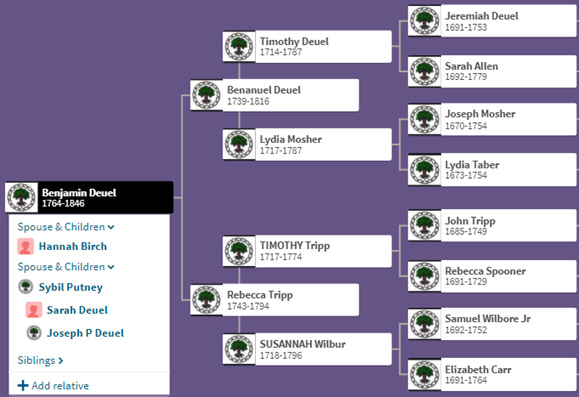
I introduced you to the Deuel and Tripp families in my essay on Bristol County, Massachusetts, a few weeks ago. That story ended with the relocation of both families to Dutchess County, New York, sometime around 1739. The key figures in this story are four of my 6th great-grandparents: Timothy Deuel (1714-1787), Lydia Mosher (1717-1787), Timothy Tripp (1717-1774), and Susannah Wilbur (1718-1796).
Timothy Deuel and Lydia Mosher were married in Dartmouth, Bristol County, Massachusetts, in 1737, and had two children there – Judith, born in 1738, and my 5th great-grandfather Benanuel Deuel (1739-1846), before moving to Dutchess County. They settled in the village of Millbrook in the town of Washington, where their next child, Sarah, was born in 1742. The Deuel family is later identified with land in Pine Plains (a town about 20 miles north of Millbrook) and in the town of Stanton (between Millbrook and Pine Plains).
The trajectory of my other 6th great-grandparents, Timothy Tripp and Susannah Wilbur, follows a similar path. Timothy’s family were Quakers with deep roots in Dartmouth, and Susannah’s family were Quakers in Rhode Island. (This is a good time to remember that the border between Massachusetts and Rhode Island was relatively fluid at this time – Bristol County was part of Massachusetts until 1747, when the British Crown transferred the area to Rhode Island. As I discussed in my earlier essay on Bristol County, all these areas were on the shores of Narragansett Bay and there was little to distinguish a Massachusetts town from a Rhode Island town.) They married in Tiverton, Rhode Island (Susanna’s home) in 1741 and moved to Dutchess County before their first child was born in 1742. My 5th great-grandmother Rebecca Tripp (1743-1794) was their fourth child.
A Diversion to Satisfy My Curiosity
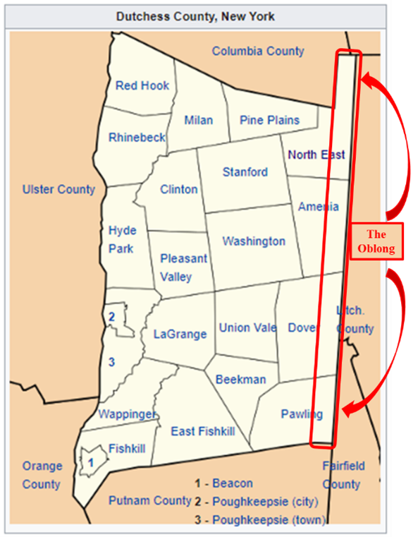
So now I had a big question – why did these people move, apparently as a group, from Bristol County, Massachusetts, to Dutchess County, New York, in 1740? I found some clues in looking at the early history of Dutchess County. (My major source for these insights was this article https://hvmag.com/life-style/history/the-oblong-in-pawling-a-history-of-a-quaker-hill-community-in-the-hudson-valley/). Throughout the colonial era, the colonies of New York and Connecticut had argued about the exact location of their border. The Taconic and Berkshire Mountains in western Connecticut and Massachusetts had impeded early transit from those colonies into New York. In 1731, the border issue was settled, with Connecticut gaining the odd panhandle that juts into New York along the coast. In return, New York got an equivalent amount of land, about two miles wide by 60 miles long, that ran from the panhandle up to the Massachusetts border. This has always been called the Oblong.
This history of the creation of the Oblong is important because the border dispute meant that no one really owned the land. It was not included in any of the original land patents, so it was simply on the market. This is where the Quakers came in – in particular, Nathan Birdsall, a surveyor born on Long Island who came to the area with his wife and young child in 1728. Birdsall made his way to Danbury, Connecticut, and had intended to head west into New York, but found that there was no road to take him where he wanted to go. He transferred his belongings from his wagon to horseback, and made his way the 20 miles or so from Danbury to what would become Quaker Hill, in Dutchess County. The settlement of the boundary dispute meant that the land was available for purchase, and he got the word out to Quaker communities all over New England – including, presumably, Bristol, Massachusetts. By 1740, there were several dozen families there, which meant there were enough Quakers to establish a meeting of their own. The Oblong Meeting House was built in 1742, in the town of Pawling.
With the Quaker lore to guide me, I then looked to the history of Bristol, Massachusetts, and found that the town had been an early stronghold of Quakers in America. George Fox founded the Religious Society of Friends – derisively called “Quakers” because they “trembled at the word of the Lord” – in England in the 1650s. Within a short time, Quakers began to come to the colonies, where they were met with hostility and treated as criminals because they disagreed with the prevailing Puritan religious and political authorities. In the early years, Quakers were scorned, vilified, exiled, and executed in Massachusetts. Giving aid to Quakers was an offense against society, and the perpetrators were often fined or flogged. Quakers were in Dartmouth in Bristol County by 1671, and their first meeting house was built there in 1699. Before that, meetings were held in private homes. Although persecution of Quakers apparently decreased after the passage of religious toleration laws in several colonies in the 1720s, many Quakers had had enough. My ancestors, as Quakers in Dartmouth, must have heard the call from Nathan Birdsall, as they were all in Dutchess County by 1740.
Okay – Now Back to my Ancestors in Dutchess County
With what I have come to know about the Quaker connection that brought my ancestors to Dutchess County, I can now document my ancestors more fully. The Swarthmore College digital collection of The Records of New York Yearly Meetings provided me with lots of evidence that dozens of my ancestors were active Quakers in Dartmouth for several decades. Here’s the link to that collection: http://www.swarthmore.edu/Library/friends/hazard/instructions.html?fbclid=IwAR0HaD3MaixyzjWk88a0sRCPAbXu0rQ-oceTWIhxbdxZfofpuwZJQau89G4
Timothy Deuel and Lydia Mosher had seven more children in Dutchess County over the next dozen years. Their son Benanuel (my 5th great-grandfather, mentioned earlier in this essay) married Rebecca Tripp (also mentioned earlier) in Dutchess County in 1758. Benanuel and Rebecca had 12 children in Dutchess County, including my 4th great-grandfather Benjamin Deuel (1764-1846), who was their third child. Benanuel served in the American Revolution from Dutchess County. By 1800, Benanuel was living in western New York with three family members – probably one of his daughters and two of their children, although I can’t prove that for sure. I can’t find Benanuel in the 1790 census, but I suspect he moved to western New York after Rebecca’s death in 1794. He lived on bounty land he had been granted for his Revolutionay War service.
Timothy Tripp and Susannah Wilbur had six children in Dutchess County, including Rebecca, as mentioned above. All of them stayed in Dutchess County, so far as I can tell.
These families come together in the person of Benjamin Deuel – the son of Benanuel Deuel and Rebecca Tripp, and the grandson of my Quaker 6th great-grandparents who came to Dutchess County in 1739-41. Benjamin had married Sybil Putney (1776-1820) and was living in Saratoga County, New York, by 1800. He later moved further west, to Oneida County by 1810, Onandaga by 1820, and then to Wayne County by 1820. He died in Cayuga County in 1846.
I’ll continue his story in a later essay on Onondaga County.