
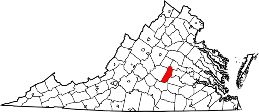
Cumberland County, Virginia

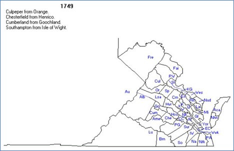
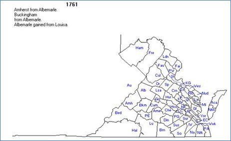
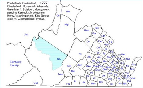
Cumberland County, Virginia, was formed from Goochland County in 1748. It was named after William Augustus, Duke of Cumberland, who was the second son of King George II of England. Cumberland County was truly in the western frontier of Virginia in the late 17th and early 18th century. Although settlement in Virginia had been going on for almost 100 years, very little was known about Virginia beyond the fall line that runs through the state – from Washington, DC, through Fredericksburg and then Richmond. Travel over waterways made settlement fairly easy within 90 miles of the Atlantic seaboard; the challenges of traversing the falls and then travelling up much narrower and shallower rivers impeded westward exploration.
Sir William Berkeley, who served Virginia as Governor from 1642-1652 and then again from 1660 until his death in 1677, had eyes on the west. In 1669 and 1670, he commissioned John Lederer, a German physician who had come to Virginia in 1668, to lead a series of expeditions to the Appalachian Mountains in the western part of the state. At that time, the consensus of European thinking was that the western sea (variously identified as the Pacific or the Indian Ocean) was not more than a two-week trip from the eastern seaboard. When Lederer returned with accounts of mountains that stretched out, seemingly endlessly, from the first ridge of the mountains that he and his party ascended, he dashed hopes that the riches of the Orient could be easily accessed through Virginia. However, he raised hopes about the abundance of the land that lay to the west, thus spurring later exploration and settlement of these unsettled lands. Lederer’s expeditions led him directly through what would become Augusta County. By the 1720s, the land in Cumberland County was being surveyed and sold to the descendants of early Virginia settlers.
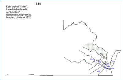
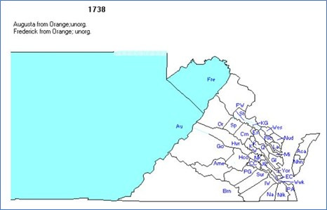
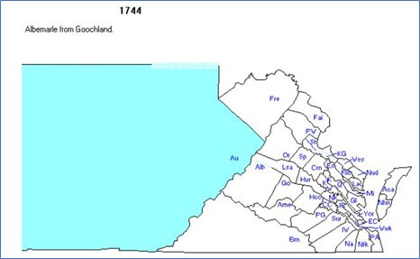
Evolution of Counties in Virginia
It is important to know when counties were founded in order to know where to look for records. The following sequence of maps (all taken from http://www.mapofus.org) shows this evolution in the central part of Virginia. One important thing to realize about county formation – new counties are established as populations grow, because people need to be able to get to the county seat easily for activities like forming local militias.

A (Very) Little History
I’ve already talked about the history of the exploration of Virginia as it impacted Cumberland County. I don’t know very much about events in Cumberland County during the 18th century. The French and Indian War (1756-1763) certainly impacted Cumberland County as troops moved toward the Ohio Valley, where most of the fighting occurred. Lord Dunmore’s War (1774), which was a series of skirmishes between native tribes and white settlers as settlers moved through the Shenandoah Valley and over Cumberland Gap into Kentucky, also almost certainly impacted Cumberland County, as it was located on a series of trails to the west. But I don’t know details about this.
The American Revolution also impacted Cumberland County. Hundreds of men from Cumberland enlisted in the American army – including my 5th great-grandfather John Walton, Jr., about whom I’ll talk in a little bit.
Yes, he is Grandpa John-Boy.
So far as I can determine, no significant engagements of this war occurred in Cumberland County. The closest the war came to Cumberland County was in 1781, when British troops under the command of General Banestre Tarleton forayed into western Virginia in an attempt to catch up with Thomas Jefferson and the Virginia colonial government, which had fled Williamsburg ahead of the British occupation of the city in 1780. In another raid, Tarleton left Cobham, Virginia (just east of Charlottesville) to conduct an attack in Bedford County in an effort to seize arms and intercept any American troops they might encounter. Tarleton’s orders then were to return to Suffolk, Virginia (near Norfolk). These raids and excursions circled Cumberland County, but apparently did not involve the County directly.
My Ancestors in Cumberland County
This chart shows my ancestors in Cumberland County.
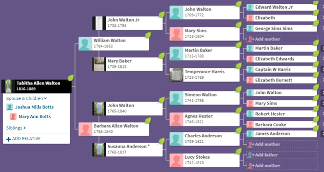
The Walton Family
My “anchor” ancestors in Cumberland County are members of the Walton family. It is not clear who the first Walton in Virginia was; there were at least eight men named John Walton in the colony in its early years, and other men named George and Robert Walton. No one has been able to prove who the earliest of my line of Waltons in America was – but recently, a historian named Wilmer L. Kerns has made a valiant effort to prove this line. In 2005, he published a book called Waltons of Old Virginia: and Sketches of Families in Central Virginia, in which he seeks to provide sources for the information floating around about the Walton family in Virginia. I am indebted to him for much of what I understand about the Walton family, which I was able to check out from the Swem Library at William and Mary.
My Walton story is too complicated to recount here, but I want to tell you about one of my Walton ancestors – my 6th great-grandfather (and 5th great-uncle) Simeon Walton (1741-1798). Simeon was an early Baptist minister in Amelia County (adjacent to Cumberland County). Here’s what an 1810 book (A History of the Rise and Progress of Baptists in Virginia, by Robert Baylor Semple) had to say about Simeon:
He was a man of note, in his day and generation. In point of education he had opportunities above many of his companions in the ministry. Having a relish for literary pursuits, he improved his mind above what might have been looked for from his school learning. Being a good mathematician, he was appointed to discharge the duties of county surveyor, in Amelia the place of his residence, for a length of time. Being a ready scribe, he was clerk to the Middle District Association, for many years. There was a considerable intimacy between him and elder John Williams. They were kindred spirits. As a preacher, he was thought to be above mediocrity; though in this character, he did not shine as brightly as might have been expected, considering his cleverness in other points. He resided in Nottoway church, as pastor, for many years. But in 1795, he moved to Kentucky; where, in March 1798, God took him to himself. He was a good and faithful servant.
I learned more about Simeon along the way. In 1781, he became a member of a group of 200 Virginia Baptists called the “Traveling Church,” which moved from the Fredericksburg area of Virginia to Kentucky. I know about this journey because the founders of this group, Rev. Lewis Craig and Capt. William Ellis, wrote “The Travelling church: an account of the Baptist exodus from Virginia,” a first-hand account of the travels of this group.
This book provides stunning information about the drive to move West after the American Revolution. Its depiction of the gathering of church members – described as “men, women and children, slaves, pack horses, cattle, dogs, and loaded wagons as had never been seen in the county before.” -- on “farewell Sunday” in September of 1781, at Upper Spotsylvania Baptist Church – is both inspiring and heartbreaking. This church was often called “Craig’s Church,” because of the importance of Lewis Craig to this church.
After a day-long ceremony to see off the parishioners who were heading to Kentucky, the group camped for the night on the church grounds – the first night of many weeks of camping that were to follow – and left the next morning. The authors compare this movement to that of the “greater church” as it “journeyed from Egypt but ensanguined plains of Canaan.” There are no records that show how and why this church decided to move, but they did move. They had even determined where they were going to settle – some were heading for the area of Logan’s Fort in central Kentucky (in what is now Lincoln County), and others a few miles east of Lexington. Simeon was one of probably a dozen preachers who were part of this group. The authors also note that many more Baptists followed in the path of the “Travelling Church,” and Simeon and Agnes moved permanently in 1795.
The rest of this short book recounts the story of this trip. The church members took with them most items pertaining to the Spotsylvania church – including the church books and records, its communion service, and the pulpit Bible. Much of what was important to this church was packed up and taken to Kentucky – so much so that the Upper Spotsylvania was “without either congregation or constitution.” In addition to the 200 church members, there were an estimated 300 or more additional travelers.
The route they traveled went through the Virginia Piedmont – Gordonsville and Charlottesville and on to Lynchburg on the James River. They crossed the Blue Ridge at Buford’s Gap (the route of modern Virginia Route 460, near the Peaks of Otter.) From there, they followed the Great Wagon Road south through the Shenandoah Valley until the Wilderness Road (the route first traversed by Daniel Boone) headed in a southwesterly direction toward the next range of mountains. At Fort Chiswell (near modern Wytheville), they had to give up their wagons and travel over the next ranges of mountains by foot and packhorse. The road was rough, and the men and slaves in the group had to go ahead of the main group to clear away rocks and stumps and fallen trees.
It had taken the group three weeks to travel this far – and now the party had received word that increasing activity on the part of the “savages” along the route meant that it was too dangerous at that time to make their way into Kentucky. The group had hoped to cross the mountains before winter weather set in, but that was not to be. While they were stopped in Holston (near modern-day Abingdon, just a few miles north of the Tennessee border), they encountered a group of Baptists from the same general area of Virginia they were from. This group had started for Kentucky almost a year earlier but had also been delayed by threatened Indian troubles.
It was while the group was halted at Abington that they got word of the British surrender at Yorktown. This was an occasion for much rejoicing; many members of the group had family members who had been involved in the fighting – in fact, several of Simeon’s brothers had served as soldiers in the war.
After waiting a few weeks, the group decided to keep heading west, willing to trade off the dangers of bad weather against the apparent retirement of the Indians to winter quarters. They followed the route of the Wilderness Road, which dipped into Tennessee before heading back into Virginia and on to Kentucky. They soon endured the first attack by the Indians – they repelled the attackers, but not without the loss of the life of one of their sentries. Days of bad weather followed – rains that swelled the streams, increased cold, and the resulting illnesses. Their food rotted, and for days on end they existed on the meat procured by their hunters and by the beef from their dwindling herd of cattle.
Under these conditions, it took the group three weeks to travel the 30 miles to the Cumberland Gap. By this time it was snowing, but they were afraid to light fires for warmth or cooking when they camped, for fear of Indians. Under these conditions, they could travel only a few miles a day, but they were encouraged that they were past the last great mountain ridge and were actually in Kentucky. They only had 50 miles to go to reach the first blockhouse on the trail, where they would find warmth and safety. Reaching this objective was a tremendous relief to them. They quickly found a place to settle and, after clearing a spot in the woods, they established “Craig’s Station,” where they worshipped together on the second Sunday in December 1781, using the Bible they had brought with them from Spotsylvania. This was the first church meeting in central Kentucky.
It was only a couple of years later that most of this congregation moved to South Elkhorn (about five miles from Lexington), where they established another church. Ten years later, Reverend Craig (the leader of this group and a co-author of the book I’m summarizing here) moved to Mason County, Kentucky, and later founded a church in what would become Bracken County. Simeon (remember him?) and Agnes would settle near this church when they moved permanently to Kentucky a couple of years later.