Culpeper County, Virginia

Culpeper County was established in 1749, on land taken from Orange County. The county is named for Lord Thomas Culpeper, second baron Culpeper of Thoresway, governor of Virginia from 1677 to 1683 and a proprietor of the Northern Neck.
This is how Wikipedia describes the early years of Culpeper County:
“In May 1749, the first Culpeper Court convened in the home of Robert Coleman, not far from where the Town of Culpeper is presently located. In July 1749, 17-year-old George Washington was commissioned as the first County surveyor. One of his first duties was to lay out the County's courthouse complex, which included the courthouse, jail, stocks, gallows and accessory buildings. By 1752 the complex stood at what is presently the northeast corner of Davis and Main Streets. The courthouse village was named the Town of Fairfax after Thomas, Sixth Baron Fairfax. At the Virginia convention held in May 1775, the colony was divided into sixteen districts. Each district had instructions to raise a battalion of men "to march at a minute's notice". Culpeper, Orange, and Fauquier, forming one district, raised 350 men who came to be called the Culpeper Minute Men. The Minute Men, marching under their flag depicting a rattlesnake and inscribed with the words "Liberty or Death" and "Don't Tread on Me", took part in the Battle of Great Bridge, the first Revolutionary battle on Virginia soil.”
The Evolution of Counties in Virginia
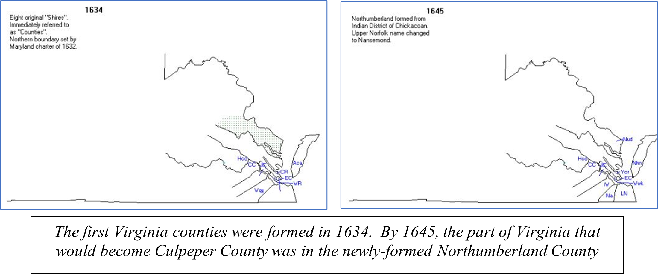
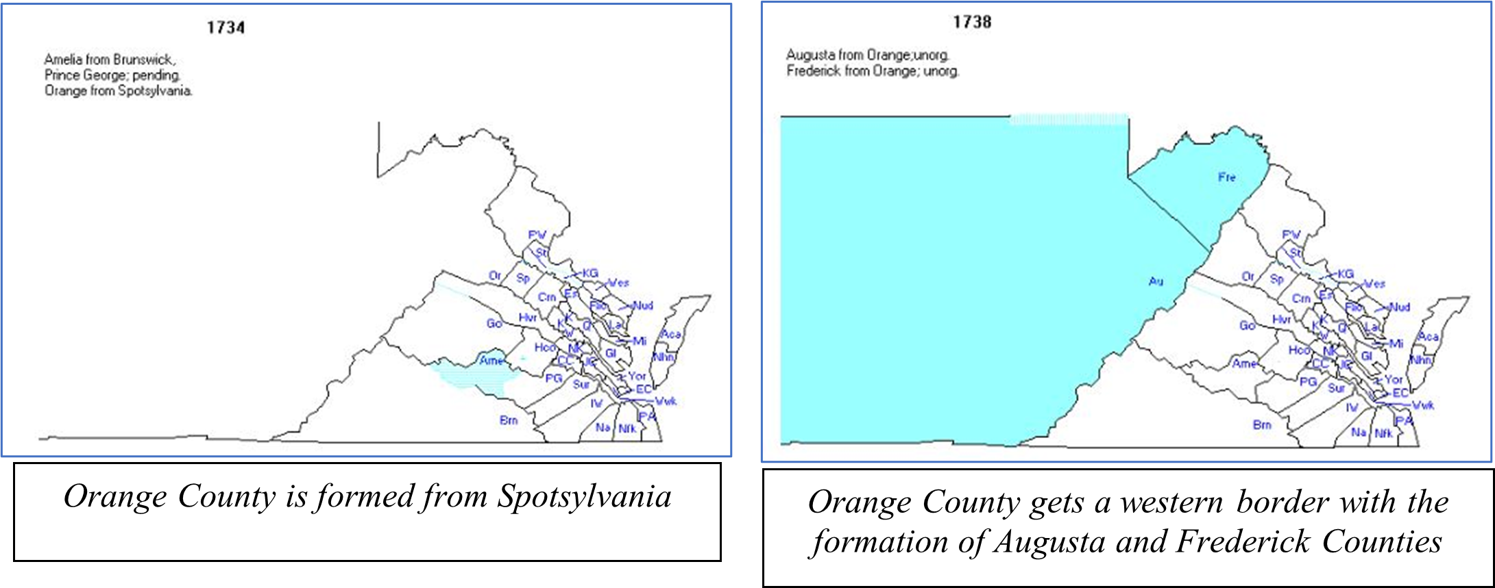
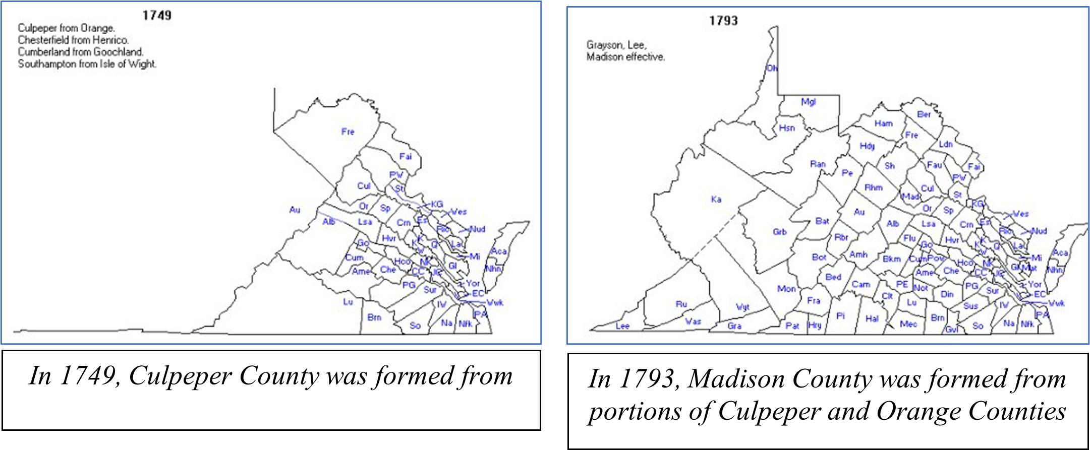
Culpeper County was not formed until 1749, 142 years after the establishment of the colony of Virginia. The counties evolved over that time in a strange way, as the following maps will illustrate. From the original eight “shires” (or counties) established in 1634, additional counties were formed in the eastern part of the state, apparently without demarcated western boundaries. These maps are taken from http://www.mapofus.org.


Presented another way – I have created what I call the “Genealogy” of Culpeper County. This is much like the “begats” in the Biblical texts in Genesis, Matthew, and Luke, except about Culpeper County instead of Jesus.
Northumberland 1645 begat Lancaster 1651 begat Old Rappahannock 1656 begat Essex 1692 begat Spotsylvania 1721 begat Orange 1734 begat Culpeper 1749 begat Madison 1792 and New Rappahannock 1838. After 1838, no significant changes were made to the boundaries of Culpeper County. I hope this clears it all up.
A (Very) Little History
The history of Culpeper County is sprinkled with the names of early Virginia aristocracy – Berkeley, Beverley, Carter, Fairfax, and others. Serious disputes over land ownership characterized the early settlement of the area that would become Culpeper County. This area of Virginia was part of the massive Northern Neck Proprietary (also known as the Fairfax Grant), encompassing more than 5 million acres between the Potomac and Rappahannock Rivers in eastern and central Virginia. This grant was first conceived by King Charles I in 1649, but it was not until the restoration of the English monarchy in 1660 that this grant was actualized by King Charles II. This grant was made to six individuals, with the bulk going to Thomas Culpeper (second baron Culpeper of Thoresway and Royal Governor of Virginia from 1677 to 1683); by 1719, however, it was in the hands of Thomas Fairfax, 6th Lord Fairfax of Cameron, who was the son of the 5th Lord Fairfax and his wife, Katherine Culpeper (the only legitimate child of former Royal Governor Thomas Culpeper).

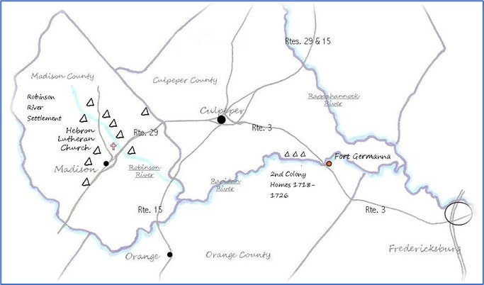
Alexander Spotswood, Lieutenant Governor of Virginia from 1710-1722, was the next leader to spotlight central Virginia. In 1714, he was instrumental in establishing the First Germanna Colony. Now in Orange County, at that time it was in Spotsylvania County, nestled against the Rapidan River which forms a southern boundary of Culpeper County. This settlement (and its second iteration, established in 1717) was part of an 86,000-acre land grant given to Spotswood by the House of Burgesses to form a buffer against encroaching French settlement in the Ohio Valley. Spotswood recruited Germans from the western part of Germany, which the 20th century would know as the Ruhr Valley, an important source of iron and coal. Spotswood encouraged these settlers to come in support of the iron works he was building in the region.

These German settlers migrated to other parts of Virginia over time, but remnants of these early German inhabitants can still be found throughout Spotsylvania, Orange, and Culpeper County. The second group of German settlers, who came in 1717, settled a bit further west (in what is now Madison County) and became engaged in winemaking. (NOTE: for the last several decades of their lives, my parents lived in Madison, less than four miles from the Hebron Lutheran Church. My sister and her husband now own my parents’ house. No one in the family (including me) was aware of our family connection to Culpeper County.)
After 100 years of its existence as a colony, Virginia had begun to experience pressure to move westward and settle additional land. In 1716, Spotswood created an expedition that came to be called The Knights of the Golden Horseshoe – a group of about 50 men and 74 horses – that was charged with exploring the Blue Ridge Mountains of Virginia and the valley that lay beyond. They moved west from Spotswood’s settlement in Germanna in the summer of 1716, crossed the mountains at Swift Run Gap, and spent a few days exploring what came to be called the Shenandoah Valley. Their expedition did not create an immediate market for land in the Shenandoah Valley and beyond, but they set the stage for later exploration and settlement of the area.
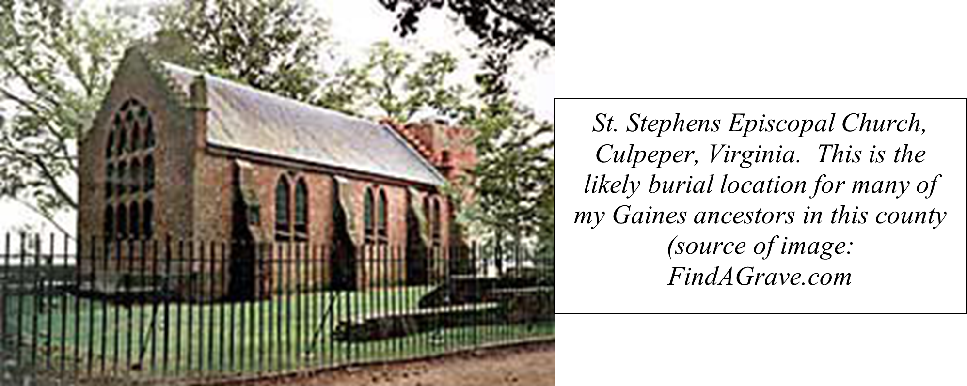
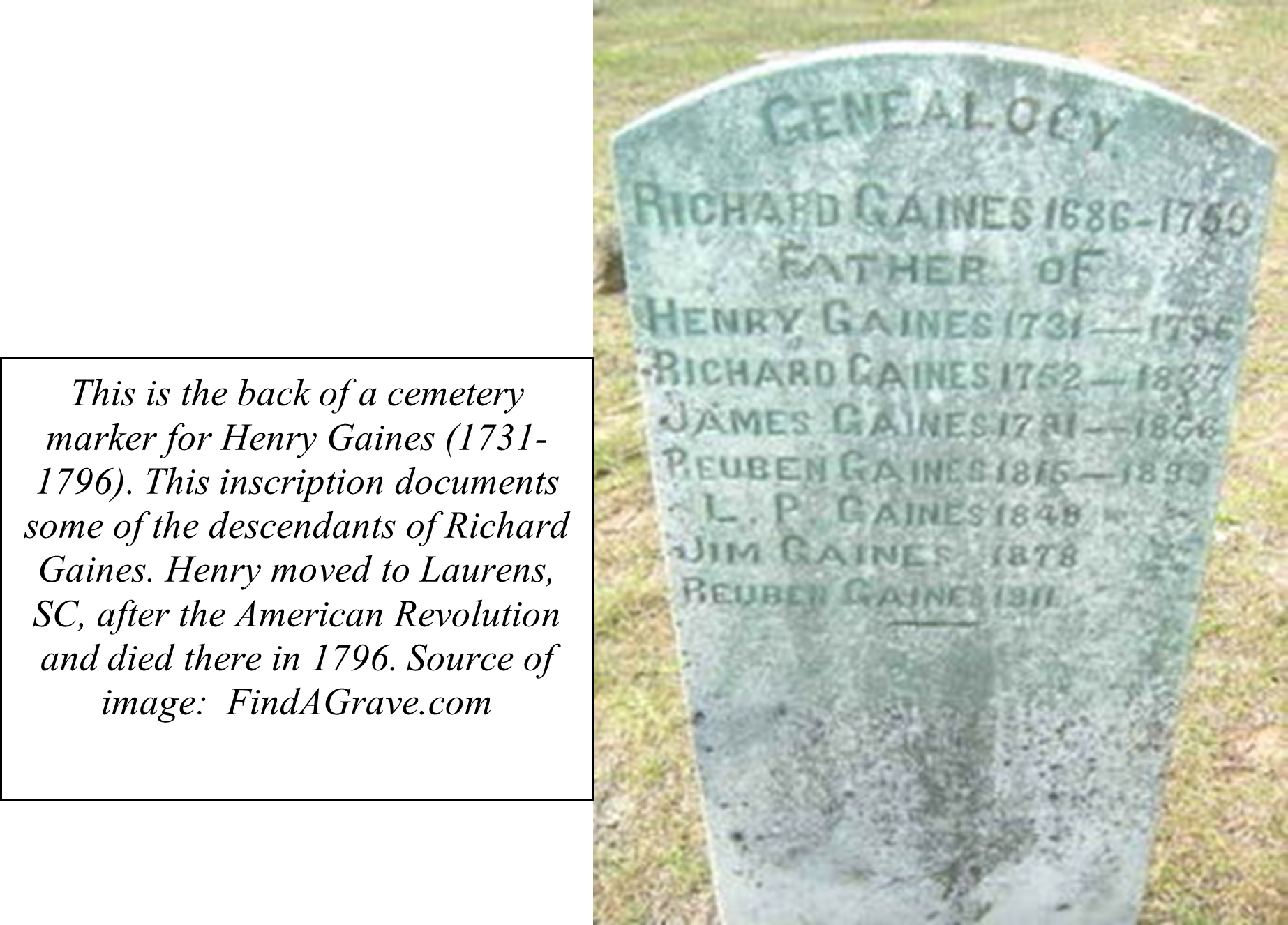
Prior to the American Revolution, a militia was formed in Culpeper; the roster of this group, called the Culpeper Minutemen, includes several men with the Gaines surname (my most prominent Culpeper family name). This militia group most famously fought at the 1775 Battle of Great Bridge, which was fought to secure access to arms in the face of British aggression. This battle was fought in the Norfolk area of Virginia, near the border between Virginia and North Carolina. Colonel William Woodford (the commander of the colonial forces at this battle), wrote in a letter published in Purdie's Virginia Gazette, December 15, 1775: "This was a second Bunker's Hill affair, in miniature; with this difference, that we kept our post, and had only one man wounded in the hand."
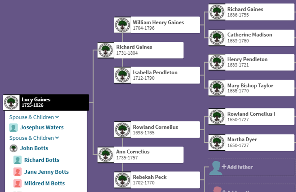
My Ancestors in Culpeper County
The following pedigree chart shows which of my ancestors spent significant parts of their lives in Culpeper County:
Many members of the Gaines family left Culpeper County after the Revolution. Many of the family members went to South Carolina; my Gaineses went to Kentucky. Other Gaines family members moved to other parts of Virginia. But the 1850 Federal Census shows 35 people with the Gaines surname still living in Culpeper, and even today there are dozens of people with the Gaines surname living there. Gainesville, Virginia (a crossroads in what is now Prince William County, Virginia), was named after Thomas Brawner Gaines, a great-grandson of my 6th great-grandfather RichardGaines (and thus my 2nd cousin 5 times removed, if I’ve calculated this correctly). While we were still living in northern Virginia in the 1980s and 1990s, we drove through Gainesville every time we visited my parents in Madison. I knew nothing about my connection to the Gaines family at the time.