
Bourbon County, Kentucky


The sun shines bright in the old Kentucky home
'Tis summer, the darkies are gay
The corn top's ripe and the meadow's in the bloom
While the birds make music all the day
The young folks roll on the little cabin floor
All merry, all happy, and bright
By 'n by hard times comes a-knocking at the door
Then my old Kentucky home, good night
[Chorus]
Weep no more my lady, oh! weep no more today!
We will sing one song for the old Kentucky home
For the old Kentucky home far away
Words and Music by Stephen Foster, 1853
Stephen Foster wrote “My Old Kentucky Home” as an anti-slavery song, picking up on the abolitionist spirit engendered in the United States by the publication of Harriet Beecher Stowe’s Uncle Tom’s Cabin the previous year. Like many of Foster’s works, this song spoke to the loss of home – felt not only by slaves sold away from their families but by everyone who was disconnected from the people they love. Modern sensibilities led to a change in the lyrics – now the “people” are gay, not just the “darkies.” But the idea remains.
This song, the Kentucky Derby, and the images of poverty from the hills of eastern Kentucky that were all over the news during the War of Poverty in the 1960s were all I really knew about Kentucky. I knew of the Kentucky bluegrass region and how it supposedly led to the breeding of wonderful horses, but I knew less about horses than I knew about Kentucky
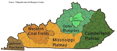
Bourbon County, just to the east of Lexington, lies in the heart of inner bluegrass country as shown on this map:
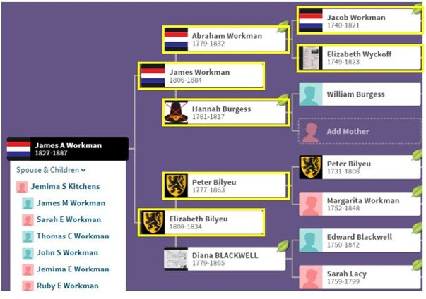
I have discovered that some of my ancestors spent time in Bourbon County on their way to somewhere else. None of my ancestors spent very much time in Bourbon County – so far as I can tell, they were there for less than a decade – from 1816 to the mid-1820s. Here’s a pedigree chart that shows my ancestors with links to Bourbon County. James A. Workman was my mother’s great-grandfather; after a few years in Bourbon County, he moved to Overton County, Tennessee. After several decades there, he moved on to Christian County, Illinois. His grandson (my great-grandfather, Thomas Calvin Workman, Sr.) was born in Tennessee, moved with his family to Illinois, and then moved on to Nebraska and Oklahoma before moving to El Campo, Texas, where he died in 1930.
The Evolution of County Boundaries in Kentucky
It should not be surprising that the evolution of country boundaries in Kentucky complicates the research process for these areas – we’ve seen this before. Here are the county boundaries for Kentucky in the time periods I’m researching (these maps are from https://www.mapofus.org/).
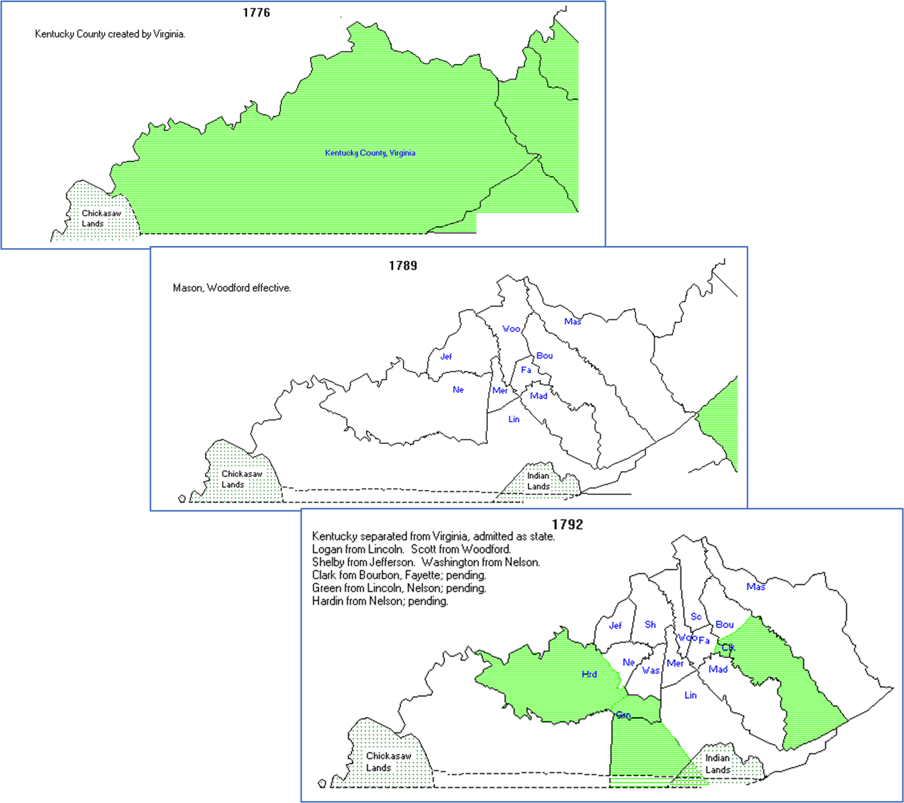
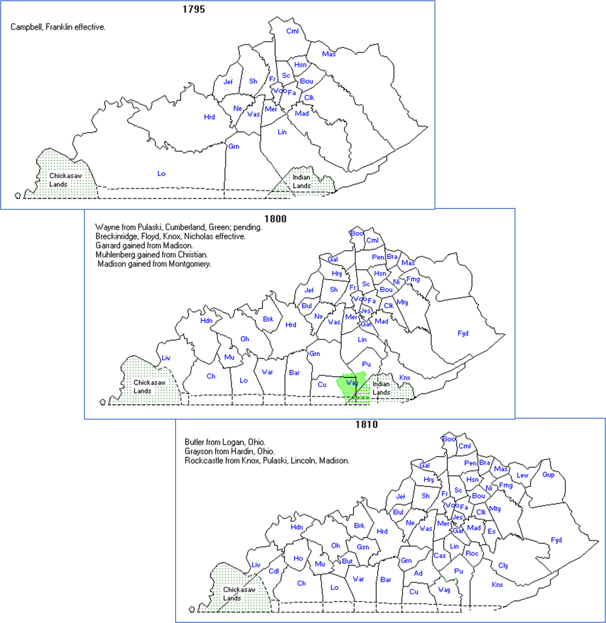
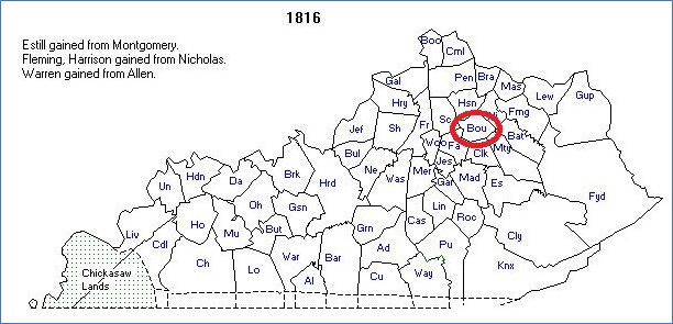
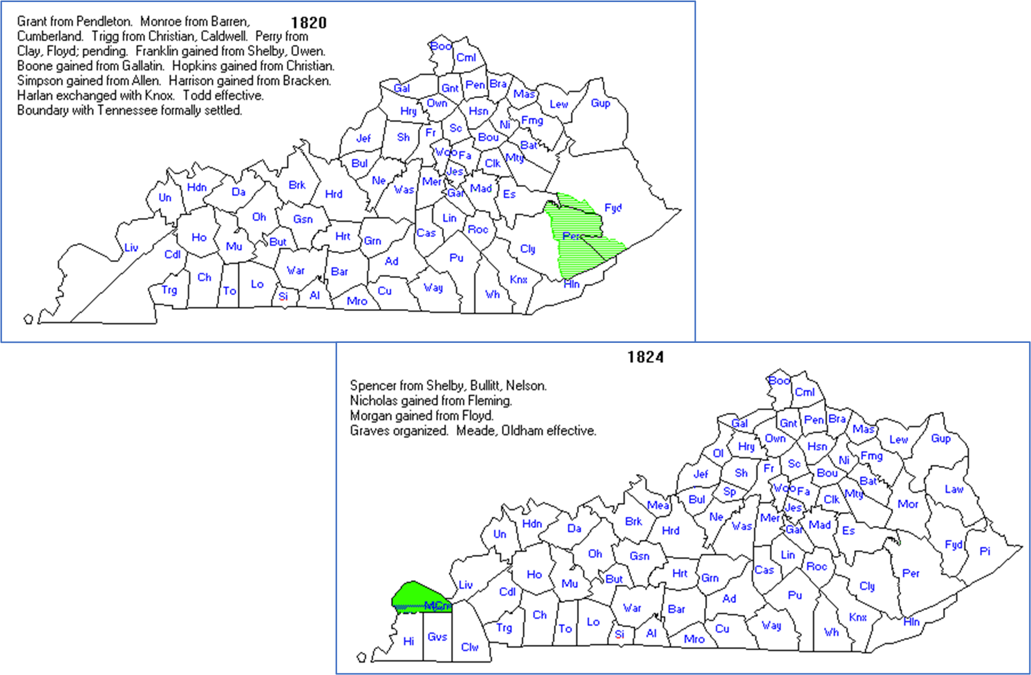
One thing that strikes me about this series of maps is how rapidly the state of Kentucky grew. New counties are added and county boundaries are redrawn when the population of the area grows or relocates significantly. I did not include all the maps of Kentucky for the time period I’m interested in; the county boundaries changed almost every year for more than 60 years, between 1785 and 1845, and about every other year from 1845 through 1905. The borders of Bourbon County, however, were pretty well established by 1800.
A (Very) Little History
It took Americans 150 years to move from their early settlements on the eastern seaboard into Kentucky. Colonies had been established at Jamestown in 1607, at New Amsterdam in 1608, at Plymouth in 1620, and in Maryland in 1634; however, the first white settlement in Kentucky, Harrods Town in what is now Mercer County in central Kentucky, was established in 1774, more than 150 years later. Exploration and settlement were delayed by both the physical challenge of traveling over the mountain ranges of the Appalachian chain and the security challenge of confronting (and eventually suppressing) the Native American tribes who were accustomed to using what some called “the dark and bloody ground” for their own purposes.
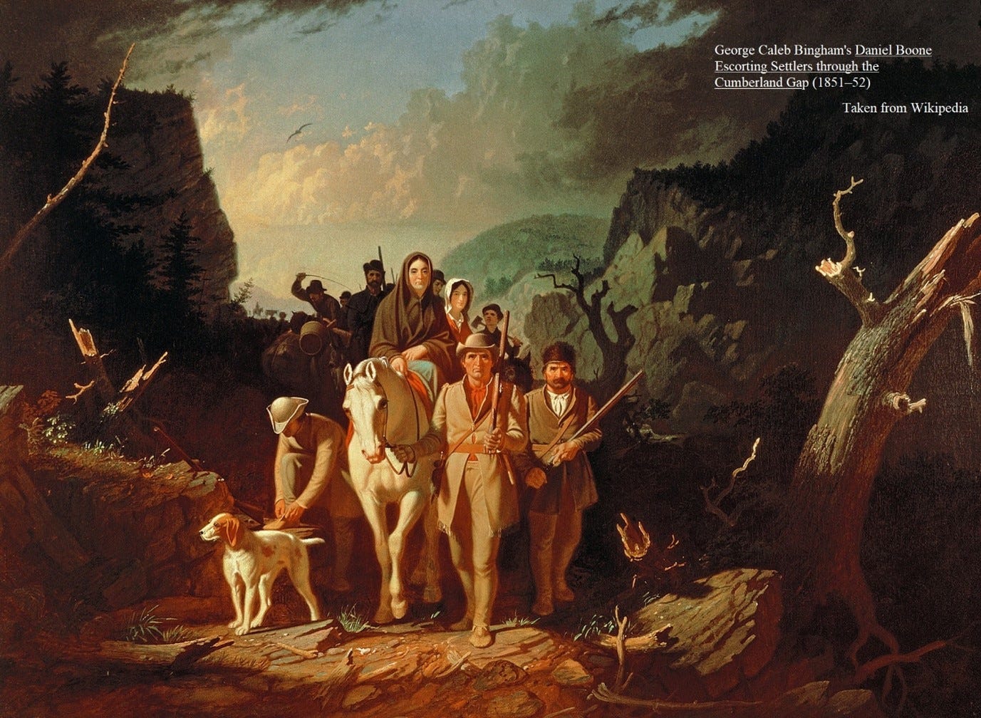
The story of the early settlement of Kentucky is well documented. In the 1750s, a 16-year-old named Daniel Boone traveled with his family from their home in Pennsylvania over the Great Wagon Road to the Yadkin River Valley in northwestern North Carolina. He served in a North Carolina militia unit from 1755-56 during the French and Indian War. He returned to Yadkin and married in 1756.
In the face of continuing raids by the Cherokee Indians in North Carolina, in 1758 Boone moved with his family to Culpeper County, Virginia (in the central part of the state). In 1762, this threat had diminished; they moved back to North Carolina and Boone began to lead regular journeys of exploration throughout the region – including his first visit to Kentucky in 1767. After several more exploratory and hunting trips to Kentucky, in 1773 he led a party of pioneers over what came to be called the Wilderness Road into Kentucky (which would be identified officially as Kentucky County, Virginia, in 1776). Boone’s little party was confronted by resistance from Indians in the area, and Boone’s son was among those killed in these encounters. After a period of conflict known as Lord Dunmore’s War, white movement into Kentucky County resumed.
This map shows the routes of these two major thoroughfares that were essential to the movement of hundreds of thousands of pioneers from the Atlantic seaboard into the Ohio and Mississippi River Valleys.

The first white settlements in what was to become Bourbon County were established in 1776, but these settlements were not permanent. The earliest settler, Thomas Kennedy, was from Virginia who had traveled by way of the Great Wagon Road and Wilderness Road to the settlement at Boonsboro. It took him several years to get to the location we now know as Paris, in Bourbon County. Other settlers in Paris were the Bedfords and the Stoners, all from Virginia.
Note: Both Bourbon County and its seat, Paris, were named to honor French assistance to the United States during the American Revolution
By 1778, permanent settlements had taken hold near the current town of Paris, which is the county seat of Bourbon County. After the American Revolution, the floodgates opened as men who had served in the war took advantage of Revolutionary War land grants in Kentucky. By 1780, the original county of Kentucky was divided into three counties – Fayette, Lincoln, and Jefferson Counties. In 1784, Nelson county was formed from Jefferson County, and in 1775, Bourbon County was formed from Fayette County. Subsequent population movements led to Bourbon County being divided again and again, until it achieved its current boundaries by the early 1790s. The population of Bourbon County was 7,837 in 1790; in 1800, 12,825; in 1810, 18,000, in 1820, 17,664, and in 1830, 18,436.
Court records from May of 1786, give us a little insight into what life was like in this frontier community. The records show, first, the sequence of events leading to the swearing in of judges, attorneys, and commissioners who were tasked with the administration of county business. The subsequent days of the court are not particularly engrossing, consisting of more administrative business relating to figuring out who lived in the county and who was going to run it.
One important duty was to set liquor and food prices in the community. According to one source, “The machinery of the courts and the new county was, at length, with the aid of the lubricating oil of frontier wisdom, fully put in motion, and, in a short time, the different departments were running smoothly.” This same source provides a list of all of the county officers. The first courthouse in Bourbon was finished and occupied in 1799.
A series of events that took place in Ohio (not in Kentucky) shaped population movements to Kentucky after the American Revolution. Between 1785 and 1795, the Northwest Indian War (also called the Ohio War or Little Turtle’s War) was waged between the newly formed United States and a confederation of Native American tribes (supported by the British) over control of the Northwest Territory (north of the Ohio River, east of the Mississippi, and south of the Great Lakes.
In 1786, George Rogers Clark and Benjamin Logan, both of whom lived in Kentucky at the time, led a force of Kentucky militia in a series of raids on Indian villages along the Mad River in southwestern Ohio. These raids, which resulted in dozens of casualties among the Shawnee Indians who were targeted, served to unite the Shawnee nation against the Americans. In the following several years, increased attacks led to the deaths of 1,500 American settlers who were traveling along the Ohio River.
A series of skirmishes over the next several years revealed the difficulty that the young American republic faced in trying to confront this challenge. In 1792, President George Washington appointed General “Mad Anthony” Wayne to build a trained militia force called the Legion of the United States.
Note: I had never heard of this unit until I started researching to write this essay.
After two years of recruitment and training, Wayne led this force against the Indian Confederacy at a location called Fallen Timbers in northwestern Ohio. The 1 ½ hour “Battle of Fallen Timbers” was not militarily decisive, but it resulted in a peace treaty between the Americans and their Indian rivals, opening up the Ohio River and the Northwest Territory for safer travel.
It is interesting and challenging to figure out what occupied the attention of early settlers in Bourbon County (and in the county seat, Paris, where many of my ancestors lived). The building and improvement of roads were clearly a major focus of the early government of Paris. The rugged Indian paths – often just wide enough for individuals to walk single-file – were widened and improved to provide passage for men on horseback and, later on, for carriages. In 1811, construction began on the National Road, along the route taken by the earlier Braddock’s Road through the Cumberland Narrows in western Maryland. This route was later improved and extended as US Route 40.
In 1830, the expenditure of federal government funds to improve the road between Maysville (on the Ohio River) and Lexington would erupt into a national controversy. During this period in American history, early lawmakers were exploring and defining the extent of federal government power. In the Maysville Road project, the federal government planned to spend federal dollars to improve the road between Maysville and Lexington (which ran through Paris); however, since this road was contained within the boundaries of one state, some people didn’t think it was a proper expenditure for the federal government, and should instead be funded by the state of Kentucky. Among the people holding this view was President Andrew Jackson, who expressed his disapproval of this encroachment of federal power by vetoing the funding bill for this project.
Early industries that developed in Bourbon County include a sawmill, a hemp factory, and what one source described as the “explosive combination” of a distillery and a powdermill operated by Benjamin Bedford. There is some lore that suggests that Bourbon whiskey is so called because it originated in Bourbon County. It is true that what we now call Bourbon was first distilled in America in Kentucky in the early 1800s, but I won’t go any further than that.
My Ancestors in Bourbon County
People connected with one of the most important of my family lines – the Workman family – lived in Bourbon County, Kentucky, between 1800 and 1832. They represent three connected surnames – Workman, Wycoff, and Bilyeu – whose members have intermarried almost from the time the immigrant ancestors for each line arrived in America in the middle of the 17th century.
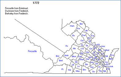
Before they lived in Bourbon County, my most significant ancestors for this story – the Workman family – lived in western Maryland. It is not possible to determine exactly how they traveled to Kentucky, but it is most likely that they followed the path taken by thousands of people before and after them. The map below shows this common route -- along the Great Wagon Road (down the Valley of Virginia) and the Wilderness Road (across the Cumberland Gap into Kentucky. I talked about the importance of this route earlier in this essay, I’m putting the map here again so you can look at it while I discuss its significance to my ancestors who came to Kentucky in those early years.
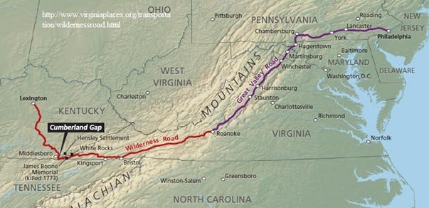
The Appalachian Mountains form a natural barrier to east-west travel in this region. There are only a few natural breaks in this chain to allow east-west travel. One of these breaks, called the Cumberland Narrows, followed a set of Indian trails from western Maryland to the Ohio River. This is near Chambersburg and Hagerstown at the top of the map. The other significant road west for people in the southern colonies of Virginia and the Carolinas ran through the Cumberland Gap in southwest Virginia.
For a long time, I assumed that my Workman ancestors had traveled from their homes in Allegany County, Maryland (about 60 miles west of Hagerstown on the map) directly across to the Ohio River, on the Ohio/West Virginia border. But I’ve changed my mind. The trails through the Cumberland Narrows in this part of the mountains had not been widened or improved at the time my ancestors moved to Kentucky. By contrast, the roads from Allegany County east to Hagerstown would have been both well-marked and somewhat improved by that time. Once in Hagerstown, the Workmans could head south on the well-traveled and relatively safe routes depicted on this map. This also explains how they ended up in Bourbon County; the county is just to the east of Lexington, marked on the map as the terminus of the Wilderness Road in central Kentucky
Huh. You gave me an idea about routes. Interesting. Thanks.